Home » Nature and Territory » Parco Storico Regionale di Monte Sole » Protected Area » History and Landscape
A brief history of the territory
The earliest evidence of settlement in or occupancy of the area dates from the Neolithic period (8th millennium BC) and the Eneolithic period (Copper Age, 4th - 3rd millennium BC). Archaeological findings indicate human habitation in the succeeding Bronze Age (3rd - 1st millennium BC) and in the Villanovan period (from the 9th century BC); more precisely, within the park at Osteria Leona, at Sperticano and on the Misano Plateau, site of the future Etruscan settlement.
In all likelihood, the impetus for settlement in the lower Reno and Setta valleys was due to their vicinity to two important communication routes, used since ancient times, linking Emilia Romagna with Tuscany: the route along the Setta-Savena ridge, which rose from Bologna towards Mount Adone, travelling across Monzuno, Mount Venere, Madonna dei Fornelli and Mount Bastione, before reaching the Futa allo Stale, and the Reno Valley route going from Bologna through Casalecchio di Reno, Sasso Marconi and Marzabotto and then along mountain ridges or hillside tracks to Pistoia.
The Etruscan settlement at Pian di Misano
Established in the mid 6th century BC, this settlement extended along a stream terrace just outside the present-day town of Marzabotto, which was also the last, reasonably-sized flat area of land before the Apennines. In the context of the flourishing Etruscan trade network, the citywas strategically positioned between central Italy, continental Europe, the Po Valley and Spina, the port city on the Adriatic, from where Etruscan ships set sail towards the Greek markets, and it was also an important center for pottery making and the processing of metals. The religious buildings of the acropolis were located on the Misanello Hill and the two nearby necropolises were used as burial grounds, adjacent to the actual city itself, featuring an orthogonal town grid and comprising houses, roads, workshops, shops and kilns.
The Celts and the Romans
The city declined gradually from the 4th century under the pressures of the Celtic invasions. The Gauls did not adapt to the urban structures organized by the Etruscans, preferring to maintain their model of villages, and the decline of the entire Reno Valley gradually followed.
This state of abandonment continued in Roman times, when the main trade routes moved to more eastern valleys. Roman settlements existed at least from the middle of the 1st century BC, for example, at Fontana, in the middle portion of the Reno Valley, and near the Etruscan city of Marzabotto, where traces of a large country house were found. Smaller findings were unearthed at Pian di Venola and along the Setta Valley at Osteria Leona and Canova di Ignano.
The area's depopulation trend only began to invert at the end of the 1st century BC, when there was a strong growth in the population near the confluence of the Setta and Reno rivers, associated with the construction of the aqueduct. Dating from around 15 BC, the Roman aqueduct is still in operation, after being restored in the 1800s, and continues to provide water to Bologna.
Afterwards, like many parts of northern Italy, the area saw the passage or settlement of numerous armies, especially at the end of the 4th century AD, with profound consequences in terms of tax collection, famines and plagues. The war between the Goths and the Byzantines had severe repercussions on the area's economic and social structures. Around the middle of the 6th century AD the eastern Bolognese mountains fell under Byzantine dominion and in the 8th century AD under that of the Lombards. Finally, with the arrival of the Franks, the lands were ceded by Charlemagne to the Papacy.
The Middle Ages
The first rural communities in these mountains were established in the mid-twelfth century. Each was led by an assembly of the tax-paying heads of family, who were expected to make decisions regarding management of the land and the population.
Between the 12th and 13th centuries the area was nevertheless controlled by the municipality of Bologna through two judiciaries: the podesterie, city magistracies, replaced in the mid-1300s by vicariates (the Caprara sopra Panico Vicariate had jurisdiction over the area of the present-day park), and the capitanato della montagna, mountain captaincy, which was responsible for the public order and had authority over moral, religious, civic and economic issues. From the 1400s this judiciary was based in Vergato.
The lords of Monzuno were key figures in this territory's medieval history, owning properties and exercising rights in numerous communities, including Elle and Grizzana, yet even more influential were the powerful counts of Panico, whose castle, first documented in 1116, stood on the hill in the Panico locality, dominating over a bend of the Reno River. The Panico family controlled a complex defense system, which included the Albareda tower house, one of the very few 13th century constructions to have survived practically intact, the settlement at Casola, the Caprara castle, Castelvecchio, the towers at Torre Lame, Casigno and Carviano and the fortified center at Le Murazze, recently identified as the Rocca delle Bedolete fortress of the counts of Panico, which preserves traces of the ancient city walls and several stone houses dominated by a 13th century tower.
They were ruthless Ghibellines who clashed violently with the rising city of Bologna and who continued to ravage the Bolognese mountains; finally, in the late 1300s, Bologna managed to extend its control over this area definitively, when the Panico family was already impoverished and dispersed.
Parish churches played an important rule during the Middle Ages. They served as the burial grounds for parishioners and, under the guidance of the parish priest and his assistants, they administered the territory. The specific area of the present-day park was administered by the parishes of Panico, Sambro and Calvenzano, the first of the three, dedicated to Saint Lawrence, enjoying a prominent position. It was located directly opposite the ancient castle of the Panico family and it had jurisdiction over the entire mountain ridge. It remains today one of the finest examples of Romanesque architecture in the Apennines.
In the Middle Ages the local population's livelihood depended essentially on growing cereal crops and raising livestock, especially sheep. Silkworm breeding and beekeeping were also common. Local artisans were mainly blacksmiths, tailors, cobblers, barbers, builders, woodworkers and saddlers. Manufacturing activities were scarce and rudimentary.
Scattered houses and small hamlets were built almost everywhere along the mountains, although the population preferred inhabiting the areas along the mountain ridges. This was quite a busy area due to the passage of pilgrims and merchants, who travelled along the route that led from Bologna to the Montovolo Sanctuary, which, at the time, was also the site of an important end-of-summer trade fair, held since the late Middle Ages. This was the Castiglione dei Pepoli route, which branched off from the other path at Panico and climbed back up the mountain ridge, reaching San Silvestro, Veggio and Grizzana and then continued through Brasimone and Setta towards Castiglione dei Pepoli, Prato and Florence; this route also led to the Boccadirio Sanctuary, frequented since the 16th century.
Another important mountain travel route was the one following the course of the Reno River along a path that roughly corresponded to the present-day state road leading from Bologna to Tuscany. This road, previously travelled by Etruscans and Romans, was known as the Saragozza high road, because it started in a street in Bologna of the same name. From Pistoia, it was referred to as the Francesca della Sambuca road, indicating its final destination in France.
Although Bologna's local government had restored the mountain road network at the end of the bloody feudal conflicts, it remained in unstable conditions for centuries, so much so that in the 1700s papal technicians were still complaining about the appalling conditions of the roads. Like all roads of those times, even these routes featured ospitali (shelters for travelers), located at intervals of about a day's walk one from the other: at Pontecchio, Sasso, Panico, Vergato, Casola, Pian di Casale, Monzuno.
The Modern Age
Even throughout the modern age, the mountain's fragile economy was based on farming and forestry activities and basic handicrafts. The main cultivations were wheat and spring-sown crops (cereals and legumes), fruit and grapes, as well as hemp. The forests provided wood, chestnuts, acorns and charcoal. Livestock provided food for humans and was used for farm work; silkworm farming was also widespread. The most common trades were those of the blacksmith, dyer, cobbler, carpenter, tailor and miller.
The entire area along the Reno Valley was also open to significant economic penetration from wealthy and influential Bolognese families; this helped consolidate relations between the city and the mountain and hillside territories, in certain cases generating a considerable amount of related activities.
During the modern period, this territory continued to be organized along the lines of the various feudal jurisdictions that had emerged in the Middle Ages, often with the introduction of privileges for certain powerful families, who would proceed to divide territorial control amongst themselves.
These lords administered justice and would speak out before the mountain captaincy to safeguard their interests, legitimate or otherwise, and those of their subjects. Occasionally masked behind false political purposes, large groups of outlaws, brigands, smugglers and common criminals would plunder and pillage the mountains, wreaking havoc amongst the populations, particularly during the 1500s.
The Modern Period
In the 1600s the territory's entire system of government that had been organized by the city of Bologna fell into decline, even if privileges and judiciaries only officially disappeared with the unfolding of the French Revolution and the subdivision in 1803 of the Reno Department into districts.
Following the Restoration, the previous administrative framework was only partially reinstated and in the mid-19th century the only municipalities in the present-day park's territory were Caprara, Monzuno and Tavernola.
Towards the end of the 1800s, driven by the availability of water resources, the construction of the railway and improvements to the road network, a number of industries began to grow in the area. Key manufacturing activities included the hemp fiber spinning and weaving factory and paper mill at Marzabotto and the hemp manufacturing factory at Pioppe di Salvaro. Nevertheless, crop and livestock farming remained the predominant means of livelihood.
The growth of these early industries led to the gradual flow of the population from the mountain ridges to the valley floors. Nonetheless, this trend was accompanied by a slight increase in population figures, which had begun in the early 1800s.
Redistribution of the population led to a number of significant administrative transformations. In fact, by Royal Decree of July 2 1882, the municipality of Caprara sopra Panico changed its name to Marzabotto, where the town hall had, in effect, already been transferred. Soon afterwards, on December 10 1882, another royal decree changed the name of the municipality of Tavernola to Grizzana, where the town hall was located.
The major public works constructed during the 1800s also impacted fundamentally on the redistribution of the population. One of the earliest projects regarded the ancient travel route running through the Reno Valley, which had become virtually impassable. The course of the modern-day Porrettana state road was repaired and in 1848 it connected with the Leopolda road on the Tuscan side. Several years later, in 1864, the Bologna-Pistoia railway line was also completed and for 70 years it served as the main travel route for passengers and goods between northern and southern Italy.
A trans-Apennine road was finally also constructed in the Setta Valley in1882, through which a brief tract of the Bologna-Florence railway line, the so-called Direttissima ("most direct"), also passed upon completion in 1934, after construction had been interrupted by the outbreak of World War I.
The early 1900s
Changes in the population patterns and economy were also reflected in the social and political transformations that swept over the Setta and Reno valley area during the late1800s and early 1900s. Modern forms of association were created through political and social organizations, with both socialist and catholic/working class ideologies, that gradually raised awareness of the possibility of fighting for better working conditions and called for the organization of labor strikes in the worksites and on the farmlands, especially in the early 20s.
The human cost of the First World War was enormous and reintegration for the returning solders was difficult, after having endured the ordeals of combat, the struggles with misery and suffering and the unkept promises of receiving land. Many inhabitants of the area found employment when construction of the Direttissima railway line resumed but once terminated, countless people were again without work and facing economic hardship. They reacted to these circumstances either by cultivating marginal land or by emigrating. The decision to migrate was also politically motivated: in the meantime, Italy's fascist government had come into power, with the March on Rome on October 28 1922. With its autarchic, repressive and military policies, the fascist regime did not improve living conditions for the local people.

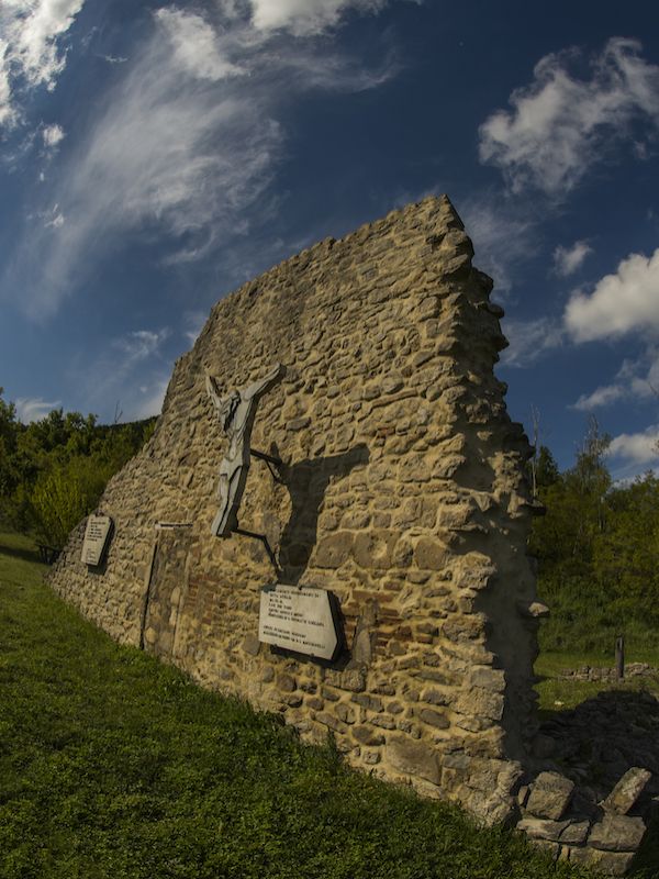
Caprara
(photo by Archivio Ente Parchi e la Biodiversità - Emilia Orientale)
(photo by Archivio Ente Parchi e la Biodiversità - Emilia Orientale)

Caprara
(photo by Archivio Ente Parchi e la Biodiversità - Emilia Orientale)
(photo by Archivio Ente Parchi e la Biodiversità - Emilia Orientale)
Caprara
(photo by Archivio Ente Parchi e la Biodiversità - Emilia Orientale)
(photo by Archivio Ente Parchi e la Biodiversità - Emilia Orientale)
2024 © Ente di gestione per i Parchi e la Biodiversità - Emilia Orientale
Piazza XX Settembre, 1 - 40043 Marzabotto (BO)
Tel. +39 051 6701260-6254811 - Fax +39 051 6254521
E-mail protocollo@enteparchi.bo.it - PEC enteparchibo@cert.provincia.bo.it
P.IVA CF 03171551207
Codice univoco per la fatturazione elettronica: UF2KK4
E-mail protocollo@enteparchi.bo.it - PEC enteparchibo@cert.provincia.bo.it
P.IVA CF 03171551207
Codice univoco per la fatturazione elettronica: UF2KK4

Privacy | Dichiarazione di accessibilità